 Guyana is divided into three counties; Essequibo, Demerara and Berbice and have four geographical regions; the interior savannahs, the highland region, the hilly sand and clay area and the low coastal plain.
 Guyana is divided into three counties; Essequibo, Demerara and Berbice and have four geographical regions; the interior savannahs, the highland region, the hilly sand and clay area and the low coastal plain.
Guyana is made up of ten administrative regions;
- Region 1 – Barima Waini,
- Region 2 – Pomeroon-Supenaam,
- Region 3 – Essequibo Islands-West Demerara,
- Region 4 – Demerara- Mahaica,
- Region 5 Mahaica-Berbice,
- Region 6 – East Berbice – Corentyne,
- Region 7 – Cuyuni-Mazaruni,
- Region 8 – Potaro-Siparuni,
- Region 9 – Upper Takutu- Upper Essequibo
- Region 10 – Upper Demerara-Upper Berbice.
BARIMA-WAINI – Region 1
The Barima-Waini region gets its name from its two main rivers. The region is predominantly forested highland, bordered at the north by a narrow strip of low coastal plain.
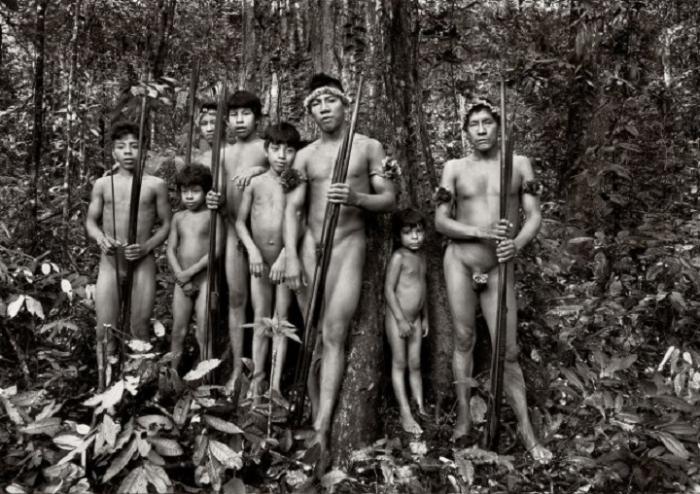
Very few people live in Region One. There are just 18,590, who live mainly in Amerindian settlements.
Logging is the region's main economic activity. The largest logging operation is run by the Barama Company, which transports timber to Demerara to be processed into plywood. There are many other timber operations, as the tropical rainforest yields many species of hardwood and other useful types of wood.
Mining for gold and diamond is also done in the forested area. Many porknockers set up dredges of various sizes.
The coast of Region One is known for its beaches, particularly Shell Beach, the only beach in the world to host four species of sea turtles during their nesting period from March to July. One type, the Olive Ridgley, is almost extinct. Another type, the Grant Letterback, is the world's largest turtle. The Scarlet Ibis, the national bird of Trinidad and Tobago, is also a common sight on these beaches.
POMEROON-SUPENAAM – Region 2
The Pomeroon-Supenaam region comprises forested highland and low coastal plain, but also takes in a small portion of the hilly sand and clay region.
The 42,769 people of this region live in Amerindian settlements and more established villages concentrated along the coast. The town of Anna Regina, on the west bank of the Essequibo River, grew out of a government land development scheme and is made up of former plantations such as Henrietta, Lima, La Belle Alliance.
The Tapakuma Project in this Region links the Tapakuma, Reliance and Capoey lakes into one large conservancy, which supplies irrigation water for rice fields which dominate Region Two. One of Guyana's largest rice producers, Kayman Sankar Ltd operates in this region, producing rice not only for local consumption, but also for export to other countries of the world.
Besides rice farming, some people cultivate coconuts and care for beef and dairy cattle. Timber production is conducted on a very small scale in this region. Not surprisingly, the Region is known as 'the Rice land'.
ESSEQUIBO ISLANDS-WEST DEMERARA – Region 3
The Essequibo Islands-West Demerara Region is made up of the islands in the Essequibo River such as Leguan and Wakenaam, and the Western portion of mainland Demerara. It is made up of low coastland, hilly sand and clay, and a small portion of forested highland regions.
This Region has a population of 91,328 people who live in villages, many along the coast. Rice farming is predominant, with small amounts of sugar and coconut cultivation.
The Boerasirie Extension Project converted the Boerasire Conservancy and the Canals Polder Conservancy into a single reservoir, and reclaimed thousands of hectacres of land, suitable for farming. The water from the conservancy is used during the dry seasons for irrigation.
Sugar cane and coconuts are cultivated on a smaller scale and there is also beef and dairy farming.
DEMERARA-MAHAICA – Region 4
he Demerara-Mahaica Region extends East of the Demerara River to the Western bank of the Mahaica River, and is predominantly low coastal plain, with a small portion of the hilly sand and clay region further inland.
The population is concentrated along the coastland, particularly in Georgetown, the capital city, which has a population of 56,095. The population of Region Four is 297,162.
Guyana's administrative and commercial activities are concentrated in this Region, especially in and around Georgetown, the main port.
There are many sugar estates, such as Diamond, Enmore and La Bonne Intention, owned and controlled by the Guyana Sugar Corporation (GUYSUCO). Some residents of this region work on coconut estates, and many people have their own kitchen gardens. Cattle are reared in small amounts for beef and diary purposes.
MAHAICA-BERBICE – Region 5
The Mahaica-Berbice Region extends east of the Mahaica River to the west bank of the Berbice River. A large part of the region is low coastal plain. Further inland lie the Intermediate Savannahs and hilly sand and clay region.
The population of Region Five: 49,498, is much lower than in Region Four.
Rice farming is the main economic activity of this region, followed by sugar and coconut farming, and beef and dairy cattle ranching. The Region has a water conservancy project aimed at improving the drainage and irrigation of the area. Great dams were erected across the headwaters of the Mahaica, Mahaicony and Abary Creeks to prevent the flooding of the farmlands in front of them during the wet seasons. During the dry seasons, the dams are opened to allow the land to be properly irrigated.
Amerindians living in inland settlements make beautiful nibbi furniture, tibisiri baskets and other craft items, which they sell to earn their living.
EAST BERBICE-CORENTYNE – Region 6
The East Berbice-Corentyne Region is the only one to include parts of all the four natural [geographic] regions: coastal plain, intermediate savannah, hilly and sandy clay area and forested highland. It is also the only Region with three towns: New Amsterdam, Rose Hall and Corriverton. The population of the Region is 142,839.
This Region, an important rice-producing, cattle-rearing and sugarcane-producing area, is very difficult to drain and irrigate. Because of this, the Torani Canal was dug to join the Berbice River and the Canje Creek. Water flows between the two and provides adequate water for irrigating the land between them.
The area of Black Bush Polder, which used to be a large swamp, was established as a land development scheme. The Government of Guyana gave people land for houses and for farming rice and their own kitchen farms.
Herds of cattle are reared for beef and dairy on the Intermediate Savannahs. Many of the other resources of the Region are not fully exploited. Logging is only conducted on a small scale, although the seasonal and montane forests of this Region can yield a variety of timber.
CUYUNI-MAZARUNI – Region 7
The Cuyuni-Mazaruni Region contains two of the four natural regions: forested highlands and a small portion of the hilly sand and clay region.
This Region brings to mind the majestic Pakaraima mountain range. Mount Roraima (2,810 metres high, standing at the point where Guyana, Brazil and Venezuela meet) and Mount Ayanganna are in this mountain range.
Most of the 15,342 people of this Region are involved in mining for gold and diamonds. Omai Gold Mines Ltd, which extracted 250,642 ounces of gold last year [1994], is the biggest gold producer in this Region, and in Guyana.
Under the Upper Mazaruni Hydroelectric Scheme, a hydroelectric plant was to provide electricity for the Region was planned, but it has not yet been built. It would be a great asset to the Region's development.
There are eight Amerindian settlements in the area of the Pakaraimas, where crops are grown. These crops supply the settlements and gold and diamond mines in the Region.
POTARO-SIPARUNI – Region 8
The Potaro-Siparuni Region gets its name from the Potaro and Siparuni Rivers, which are tributaries of the Essequibo River.
Predominantly forested highland with a small portion of hilly sand and clay, this region is home to the famous Kaieteur and Orinduik Falls. The Kaieteur is one of the highest single-drop waterfalls in the world, and it is one of the beautiful sights in the Guyana. The waterfalls of this region are great tourist attractions.
The people of this region, merely 5,737 in number, are involved in gold and diamond mining and forestry. Mazda Mining Company Ltd has the largest operation in this region.
Many of these mining companies are destroying the rivers they work in especially the Essequibo and Konawaruk Rivers.
The Iwokrama Rainforest Project is partly located in this region. The project studies how the rainforest can be used in the country's development (for example, by providing timber) without being destroyed or depleted.
UPPER TAKUTU-ESSEQUIBO – Region 9
The Kanuku and Kamoa highlands and the vast Rupununi savannahs make up the Upper Takutu-Upper Essequibo region. The forested Kanuku Mountains divide this Region in two. The north savannahs are about 2,000 square miles in area, and the south savannahs are 2,500 square miles.
The population of 15,087 lives in scattered Amerindian villages and land settlement schemes.
Because of the grassy savannahs, the Rupununi is considered to be 'cattle country'. Most of the cattle are farmed to produce beef, and a few are kept for milk. There are large ranches at Aishalton, Annai, Dadanawa and Karanambo. Much of the beef produced here is sold in neighbouring Brazil, because transportation to the other regions of Guyana, especially Region Four, is very expensive.
The people of this region also mine semiprecious stones among the foothills of the Kamoa Mountains and among the Marundi Mountains. A wide variety of craft is produced in many of the seventeen Amerindian villages, and sold mainly to Brazil.
In Region Nine, you can see the Giant River Otter, the Arapaima (the largest freshwater fish in the world) and the black Cayman.
UPPER DEMERARA-UPPER BERBICE – Region 10
The inland region of Upper Demerara-Upper Berbice contains the largest portion of the hilly sand and clay area. Guyana's principal bauxite deposits are found in the White Sands area.
The 39,106 people of this 'bauxite region' work mainly with bauxite companies Linmine (at Linden and Ituni) and Bermine (at Everton and Kwakwani). The extracted bauxite is exported to make aluminum.
A small portion of the Iwokrama Rainforest Project is located in this Region. Cattle-rearing and forestry are also done on very small scales.
In all of these regions, the economic activities provide the people who live there with the means to earn a living. These activities also help to pay for schools and hospitals in every Region.


